Chapter 1 - THE PROBLEM AND PREPARATIONS
The Home of
the Blizzard By Douglas Mawson
Preface
Chapters:
1 - The Problem
and Preparations |
2 - The Last
Days of Hobart and the Voyage to Macquarie Island |
3 - From Macquarie
Island to Adelie Land |
4 - New Lands
| 5 - First
Days in Adelie Land |
6 - Autumn
Prospects |
7 - The Blizzard |
8 - Domestic
Life | 9
- Midwinter and its Work |
10 - The
Preparation of Sledging Equipment |
11 - Spring
Exploits |
12 - Across King George V Land |
13 - Toil
and Tribulation |
14 -
The Quest of the South Magnetic Pole
| 15
- Eastward Over the Sea-Ice |
16 - Horn
Bluff and Penguin Point |
17 - With
Stillwell's and Bickerton's Parties |
18 - The
Ship's Story |
19 - The
Western Base - Establishment and Early Adventures |
20 - The
Western base - Winter and Spring |
21 - The
Western Base - Blocked on the Shelf-Ice |
22 - The
Western base - Linking up with Kaiser Wilhelm II Land
| 23 - A
Second Winter |
24 - Nearing
the End |
25 - Life on Macquarie Island |
26 - A Land
of Storm and Mist |
27- Through
Another Year |
28 - The
Homeward Cruise
Appendices:
2 - Scientific Work
| 3 - An Historical
Summary | 4
- Glossary |
5 - Medical Reports |
6 - Finance
| 7 - Equipment
Summary (2 pages) of the
Australian Antarctic Expedition
| The
Men of the Expedition
CHAPTER I
THE PROBLEM AND PREPARATIONS
Notwithstanding the fact that it has been
repeatedly stated in the public press that the Australasian
Antarctic expedition had no intention of making the South
Geographical Pole its objective, it is evident that our
aims were not properly realized by a large section of the
British public, considering that many references have appeared
in print attributing that purpose to the undertaking. With
three other Antarctic expeditions already in the field,
it appeared to many, therefore, that the venture was entirely
superfluous.
The Expedition had a problem sketched
in unmistakable feature, and the following pages will shortly
set forth its historical origin and rationale.
The
Antarctic problem** assumed its modern aspect after Captain
Cook's circumnavigation of the globe in high southern
latitudes, accomplished between 1772 and 1775. Fact replaced
the fiction and surmise of former times, and maps appeared
showing a large blank area at the southern extremity of
the earth, where speculative cartographers had affirmed
the existence of habitable land extending far towards the
Equator. Cook's voyage made it clear that if there were
any considerable mass of Antarctic land, it must indubitably
lie within the Antarctic Circle, and be subjected to such
stringent climatic conditions as to render it an unlikely
habitation for man.
** Dr. H. R. Mill has compiled a complete
account of Antarctic exploration in his ``Siege of the South
Pole.''
Refer also to the Historical Appendix
for an abridged statement. Cook's reports of seals on
the island of South Georgia initiated in the Antarctic seas
south of America a commercial enterprise, which is still
carried on, and has incidentally thrown much light upon
the geography of the South Polar regions. Indeed, almost
the whole of such information, prior to the year 1839, was
the outcome of sealing and whaling projects.
About
the year 1840, a wave of scientific enthusiasm resulted
in the dispatch of three national expeditions by France,
the United States, and Great Britain; part at least of whose
programmes was Antarctic exploration. Russia had previously
sent out an expedition which had made notable discoveries.
The contributions to knowledge gained at this period
were considerable. Those carried back to civilization by
the British expedition under Ross, are so well known that
they need not be described. The French under Dumont D'Urville
and the Americans under Wilkes visited the region to the
southward of Australia--the arena of our own efforts--and
frequent references will be made to their work throughout
this story.
What has been termed the period of averted
interest now intervened, before the modern movement set
in with overpowering insistence. It was not till 1897 that
it had commenced in earnest. Since then many adventurers
have gone forth; most of the prominent civilized nations
taking their share in exploration. By their joint efforts
some, at least, of the mystery of Antarctica has been dispelled.
It is now a commonplace, largely in the world of geographical
concerns, that the earth has still another continent, unique
in character, whose ultimate bounds are merely pieced together
from a fragmentary outline. The Continent itself appears
to have been sighted for the first time in the year 1820,
but no human being actually set foot on it until 1895. The
Belgian expedition under de Gerlache was the first to experience
the Antarctic winter, spending the year 1898 drifting helplessly,
frozen in the pack-ice, to the southward of America. In
the following year a British expedition under Borchgrevinck,
wintering at Cape Adare, passed a year upon the Antarctic
mainland.
The main efforts of recent years have been
centred upon the two more accessible areas, namely, that
in the American Quadrant** which is prolonged as a tongue
of land outside the Antarctic Circle, being consequently
less beset by ice; secondly, the vicinity of the Ross Sea
in the Australian Quadrant. It is because these two favoured
domains have for special reasons attracted the stream of
exploration that the major portion of Antarctica is unknown.
Nevertheless, one is in a position to sketch broad features
which will probably not be
radically altered by any future
expeditions.
** For convenience, the Antarctic regions
may be referred to in four main divisions, corresponding
with the quadrants of the hemisphere. Of the several suggestions
thrown out by previous writers, the one adopted here is
that based on the meridian of Greenwich, referring the quadrants
to an adjacent continent or ocean. Thus the American Quadrant
lies between 0 degrees and 90 degrees W., the African Quadrant
between 0 degrees and 90 degrees E., and the Australian
Quadrant between 90 degrees and 180 degrees E. The fourth
division is called the Pacific Quadrant, since ocean alone
lies to the north of it.
Certain it is that a continent
approaching the combined areas of Australia and Europe lies
more or less buried beneath the South Polar snows; though
any statement of the precise area is insufficient for a
proper appreciation of the magnitude, unless its elevated
plateau-like character be also taken into consideration.
It appears to be highest over a wide central crown rising
to more than ten thousand feet. Of the remainder, there
is little doubt that the major portion stands as high as
six thousand feet. The average elevation must far exceed
that of any other continent, for, with peaks nineteen thousand
feet above sea-level, its mountainous topography is remarkable.
Along the coast of Victoria Land, in the Australian Quadrant,
are some of the most majestic vistas of alpine scenery that
the world affords. Rock exposures are rare, ice appearing
everywhere except in the most favoured places.
Regarding
plant and animal life upon the land there is little to say.
The vegetable kingdom is represented by plants of low organization
such as mosses, lichens, diatoms and alg£e. The animal
world, so far as true land-forms are concerned, is limited
to types like the protozoa (lowest in the organic scale),
rotifera and minute insect-like mites which lurk hidden
away amongst the tufts of moss or on the under side of loose
stones. Bacteria, most fundamental of all, at the basis,
so to speak, of animal and vegetable life, have a manifold
distribution.
It is a very different matter when
we turn to the life of the neighbouring seas, for that vies
in abundance with the warmer waters of lower latitudes.
There are innumerable seals, many sea-birds and millions
of penguins. As all these breed on Antarctic shores, the
coastal margin of the continent is not so desolate.
In view of the fact that life, including land-mammals,
is abundant in the North Polar regions, it may be asked
why analogous forms are not better represented in corresponding
southern latitudes. Without going too deeply into the question,
it may be briefly stated, firstly, that a more widespread
glaciation than at present prevails invested the great southern
continent and its environing seas, within recent geological
times, effectually exterminating any pre-existing land life.
Secondly, since that period the continent has been isolated
by a wide belt of ocean from other lands, from which restocking
might have taken place after the manner of the North Polar
regions. Finally, climatic conditions in the Antarctic are,
latitude for latitude, much more severe than in the Arctic.
With regard to climate in general, Antarctica has the
lowest mean temperature and the highest wind-velocity of
any land existing. This naturally follows from the fact
that it is a lofty expanse of ice-clad land circumscribing
the Pole, and that the Antarctic summer occurs when the
earth is farther from the sun than is the case during
the Arctic summer.
There are those who would impatiently
ask, ``What is the use of it all?'' The answer is
brief.
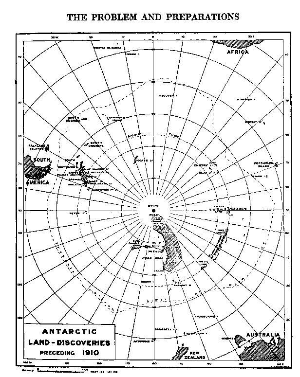
Antarctic Land discoveries
preceding the year 1910
The polar regions, like any other part of
the globe, may be said to be paved with facts, the essence
of which it is necessary to acquire before knowledge of
this special zone can be brought to even a provisional exactitude.
On the face of it, polar research may seem to be specific
and discriminating, but it must be remembered that an advance
in any one of the departments into which, for convenience,
science is artificially divided, conduces to the advantage
of all. Science is a homogeneous whole. If we ignore the
facts contained in one part of the world, surely we are
hampering scientific advance. It is obvious to every one
that, given only a fraction of the pieces, it is a much
more difficult task to put together a jig-saw puzzle and
obtain an idea of the finished pattern than were all the
pieces at hand. The pieces of the jig-saw puzzle are the
data of
science.
Though it is not sufficiently recognized,
the advance of science is attended by a corresponding increase
in the creature comforts of man. Again, from an economic
aspect, the frozen South may not attract immediate attention.
But who can say what a train of enterprise the future may
bring?
Captain James Cook, on his return to London
after the circumnavigation of Antarctica, held that the
far-southern lands had no future. Yet, a few years later,
great profits were being returned to Great Britain and the
United States from sealing-stations established as a result
of Cook's own observations. At the present day, several
whaling companies have flourishing industries in the Antarctic
waters within the American Quadrant.
Even now much
can be said in regard to the possibilities offered by the
Antarctic regions for economic development, but, year by
year, the outlook will widen, since man is constantly resorting
to subtler and more ingenious artifice in applying Nature's
resources. It will be remembered that Charles Darwin, when
in Australia, predicted a very limited commercial future
for New South Wales. But the mastery of man overcame the
difficulties which Darwin's too penetrating mind foresaw.
What will be the role of the South in the progress of
civilization and in the development of the arts and sciences,
is not now obvious. As sure as there is here a vast mass
of land with potentialities, strictly limited at present,
so surely will it be cemented some day within the universal
plinth of things.
An unknown coast-line lay before
the door of Australia. Following on the general advance
of exploration, and as a sequel to several important discoveries,
the time arrived when a complete elucidation of the Antarctic
problem was more than ever desirable. In the Australian
Quadrant, the broad geographical features of the Ross Sea
area were well known, but of the remainder and greater portion
of the tract only vague and imperfect reports could be supplied.
Before submitting our plans in outline, it will be as
well to review the stage at which discovery had arrived
when our Expedition came upon the scene.
The coast-line
of the eastern extremity of the Australian Quadrant, including
the outline of the Ross Sea and the coast west-north-west
of Cape Adare as far as Cape North, was charted by Ross
and has been amplified by seven later expeditions. In the
region west of Cape North, recent explorers had done little
up till 1911. Scott in the `Discovery' had disproved
the existence of some of Wilkes's land; Shackleton in
the `Nimrod' had viewed some forty miles of high land
beyond Cape North; lastly, on the eve of our departure,
Scott's `Terra
Nova' had met two patches of new
land--Oates Land--still farther west, making it evident
that the continent ranged at least two hundred and eighty
miles in a west-north-west direction from Cape Adare.
Just outside the western limit of the Australian Quadrant
lies Gaussberg, discovered by a German expedition under
Drygalski in 1902. Between the most westerly point sighted
by the `Terra Nova' and Gaussberg, there is a circuit
of two thousand miles, bordering the Antarctic Circle, which
no vessel had navigated previous to 1840.
This was
the arena of our activities and, therefore, a synopsis of
the voyages of early mariners will be enlightening.
Balleny, a whaling-master, with the schooner `Eliza
Scott' of one hundred and fifty-four tons, and a cutter,
the `Sabrina' of fifty-four tons, was the first to meet
with success in these waters. Proceeding southward from
New Zealand in 1839, he located the Balleny Islands, a group
containing active volcanoes, lying about two hundred miles
off the nearest part of the mainland and to the north-west
of Cape Adare. Leaving these islands, Balleny sailed westward
keeping a look-out for new land. During a gale the vessels
became separated and the `Sabrina' was lost with all
hands. Balleny in the `Eliza Scott' arrived safely in
England and reported doubtful land in 122 degrees E. longitude,
approximately. Dr. H. R. Mill says: ``Although the name
of the cutter `Sabrina' has been given to an appearance
of land at this point, we cannot look upon its discovery
as proved by the vague reference made by the explorers.''
On January 1, 1840, Dumont D'Urville sailed southward
from Hobart in command of two corvettes, the `Astrolabe'
and the `Zelee'. Without much obstruction from floating
ice, he came within sight of the Antarctic coast, thenceforth
known as Adelie Land. The expedition did not set foot on
the mainland, but on an adjacent island. They remained in
the vicinity of the coast for a few days, when a gale sprang
up which was hazardously weathered on the windward side
of the pack-ice. The ships then cruised along the face of
flat-topped ice-cliffs, of the type known as barrier-ice
or shelf-ice, which were taken to be connected with land
and named Cote Clarie. As will be seen later, Cote Clarie
does not exist.
Dr. H. R. Mill sums up the work done
by the French expedition during its eleven days' sojourn
in the vicinity of the Antarctic coast:
``D'Urville's
discoveries of land were of but little account. He twice
traced out considerable stretches of a solid barrier of
ice, and at one point saw and landed upon rocks in front
of it; but he could only give the vaguest account of what
lay behind the barrier.''
Wilkes of the American
expedition proceeded south from Sydney at the close of 1839.
His vessels were the `Vincennes', a sloop of war of
seven hundred and eighty tons, the `Peacock', another
sloop of six hundred and fifty tons, the `Porpoise',
a gun-brig of two hundred and thirty tons and a tender,
the `Flying Fish' of ninety-six tons. The scientists
of the expedition were precluded from joining in this part
of the programme, and were left behind in Sydney. Wilkes
himself was loud in his denunciation both of the ships and
of the stores, though they had been specially assembled
by the naval department. The ships were in Antarctic waters
for a period of forty-two days, most of the time separated
by gales, during which the crews showed great skill in navigating
their ill-fitted crafts and suffered great hardships.
Land was reported almost daily, but, unfortunately,
subsequent exploration has shown that most of the landfalls
do not exist. Several soundings made by Wilkes were indicative
of the approach to land, but he must have frequently mistaken
for it distant ice-masses frozen in the pack. Experience
has proved what deceptive light- effects may be observed
amid the ice and how easily a mirage may simulate reality.
Whatever the cause of Wilkes's errors, the truth
remains that Ross sailed over land indicated in a rough
chart which had been forwarded to him by Wilkes, just before
the British expedition set out. More recently, Captain Scott
in the `Discovery' erased many of the landfalls of Wilkes,
and now we have still further reduced their number. The
`Challenger' approached within fifteen miles of the
western extremity of Wilkes's Termination Land, but
saw no sign of it. The `Gauss' in the same waters charted
Kaiser Wilhelm II Land well to the south of Termination
Land, and the eastward continuation of the former could
not have been visible from Wilkes's ship. After the
voyage of the `Discovery', the landfalls, the existence
of which had not been disproved, might well have been regarded
as requiring confirmation before their validity could be
recognised.
The only spot where rocks were reported
in situ was in Adelie Land, where the French had anticipated
the Americans by seven days. Farther west, earth and stones
had been collected by Wilkes from material embedded in floating
masses of ice off the coast of his Knox Land. These facts
lend credence to Wilkes's claims of land in that vicinity.
His expedition did not once set foot on Antarctic shores,
and, possibly on account of the absence of the scientific
staff, his descriptions tend to be inexact and obscure.
The soundings made by Wilkes were sufficient to show that
he was probably in some places at no great distance from
the coast, and, considering that his work was carried out
in the days of sailing-ships, in unsuitable craft, under
the most adverse weather conditions, with crews scurvy-stricken
and discontented, it is wonderful how much was achieved.
We may amply testify that he did more than open the field
for future expeditions.
After we had taken into account
the valuable soundings of the `Challenger' (1872), the
above comprised our knowledge concerning some two thousand
miles of prospective coast lying to the southward of Australia,
at a time when the plans of the Australasian expedition
were being formulated.
The original plans for the
expedition were somewhat modified upon my return from Europe.
Briefly stated, it was decided that a party of five men
should be stationed at Macquarie Island, a sub-antarctic
possession of the Commonwealth. They were to be provided
with a hut, stores and a complete wireless plant, and were
to prosecute general scientific investigations, co-operating
with the Antarctic bases in meteorological and other work.
After disembarking the party at Macquarie Island, the `Aurora'
was to proceed south on a meridian of 158 degrees E. longitude,
to the westward of which the Antarctic programme was to
be conducted.
Twelve men, provisioned and equipped
for a year's campaign and provided with wireless apparatus,
were to be landed in Antarctica on the first possible opportunity
at what would constitute a main base. Thereafter, proceeding
westward, it was hoped that a second and a third party,
consisting of six and eight men respectively, would be successively
established on the continent at considerable distances apart.
Of course we were well aware of the difficulties of landing
even one party, but, as division of our forces would under
normal conditions secure more scientific data, it was deemed
advisable to be prepared for exceptionally favourable circumstances.
Macquarie Island, a busy station in the days of the
early sealers, had become almost neglected. Little accurate
information was to be had regarding it, and no reliable
map existed. A few isolated facts had been gathered of its
geology, and the anomalous fauna and flora sui generis had
been but partially described. Its position, eight hundred
and fifty miles south-south-east of Hobart, gave promise
of valuable meteorological data relative to the atmospheric
circulation of the Southern Hemisphere and of vital interest
to the shipping of
Australia and New Zealand.
As to the Antarctic sphere of work, it has been seen
that very little was known of the vast region which was
our goal. It is sufficient to say that almost every observation
would be fresh material added to the sum of human knowledge.
In addition to the work to be conducted from the land
bases, it was intended that oceanographic investigations
should be carried on by the `Aurora' as far as funds
would allow. With this object in view, provision was made
for the necessary apparatus which would enable the ship's
party to make extensive investigations of the ocean and
its floor over the broad belt between Australia and the
Antarctic Continent. This was an important branch of study,
for science is just as much interested in the greatest depths
of the ocean as with the corresponding elevations of the
land. Indeed, at the present day, the former is perhaps
the greater field.
The scope of our intentions was
regarded by some as over-ambitious, but knowing How far
high failure overleaps the bound Of low successes,
and seeing nothing impossible in these arrangements, we
continued to adhere to them as closely as possible, with
what fortune remains to be told.
To secure a suitable
vessel was a matter of fundamental importance. There was
no question of having a ship built to our design, for the
requisite expenditure might well have exceeded the whole
cost of our
Expedition. Accordingly the best obtainable
vessel was purchased, and modified to fulfil our requirements.
Such craft are not to be had in southern waters; they are
only to be found engaged in Arctic whaling and sealing.
The primary consideration in the design of a vessel
built to navigate amid the ice is that the hull be very
staunch, capable of driving into the pack and of resisting
lateral pressure, if the ice should close in around it.
So a thick-walled timber vessel, with adequate stiffening
in the framework, would meet the case. The construction
being of wood imparts a certain elasticity, which is of
great advantage in easing the shock of impacts with floating
ice. As has been tragically illustrated in a recent disaster,
the ordinary steel ship would be ripped on its first contact
with the ice. Another device, to obviate the shock and to
assist in forging a way through the floe-ice, is to have
the bow cut away below the water-line. Thus, instead of
presenting to the ice a vertical face, which would immediately
arrest the ship and possibly cause considerable damage on
account of the sudden stress of the blow, a sloping, overhanging
bow is adopted. This arrangement enables the bow to rise
over the impediment, with a gradual slackening of speed.
The immense weight put upon the ice crushes it and the ship
settles down, moving ahead and gathering speed to meet the
next obstacle.
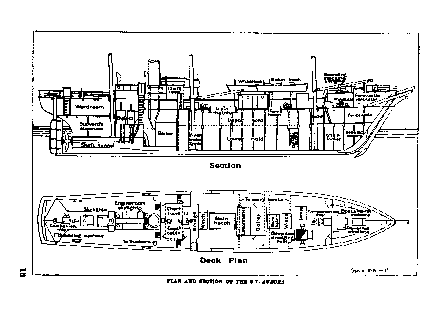
Plan and Section of S.Y.
`Aurora'
Of importance second only to a strong hull
is the possession of sails in addition to engines. The latter
are a sine qua non in polar navigation, whilst sails allow
of economy in the consumption of coal, and always remain
as a last resort should the coal-supply be exhausted or
the propeller damaged.
The `Aurora', of the Newfoundland
sealing fleet, was ultimately purchased and underwent necessary
alterations. She was built in Dundee in 1876, but though
by no means young was still in good condition and capable
of buffeting with the pack for many a year. Also, she was
not without a history, for in the earlier days she was amongst
those vessels which hurried to the relief of the unfortunate
Greely expedition.
The hull was made of stout oak
planks, sheathed with greenheart and lined with fir. The
bow, fashioned on cutaway lines, was a mass of solid wood,
armoured with steel plates. The heavy side-frames were braced
and stiffened by two tiers of horizontal oak beams, upon
which were built the 'tween decks and the main deck.
Three bulkheads isolated the fore-peak, the main hold, the
engine-room and the after living-quarters respectively.
A hull of such strength would resist a heavy strain,
and, should it be subjected to lateral pressure, would in
all probability rise out of harm's way. However, to
be quite certain of this and to ensure safety in the most
extreme case it is necessary that the hull be modelled after
the design adopted by Nansen in the `Fram'.
The
principal dimensions were, length one hundred and sixty-five
feet, breadth thirty feet, and depth eighteen feet.
The registered tonnage was three hundred and eighty-six,
but the actual carrying capacity we found to be about six
hundred tons.
The engines, situated aft, were compound,
supplied with steam from a single boiler. The normal power
registered was ninety-eight horse-power, working a four-bladed
propeller, driving it at the rate of sixty or seventy revolutions
per minute (six to ten knots per hour).
Steam was
also laid on to a winch, aft, for handling cargo in the
main hold, and to a forward steam-windlass. The latter was
mainly used for raising the anchor and manipulating the
deep-sea dredging-cable.
The ship was square on the
foremast and schooner-rigged on the main and mizen masts.
Between the engine-room bulkhead and the chain and sail
locker was a spacious hold. Six large steel tanks built
into the bottom of the hold served for the storage of fresh
water and at any time when empty could be filled with seawater,
offering a ready means of securing emergency ballast.
On the deck, just forward of the main hatch, was a deckhouse,
comprising cook's galley, steward's pantry and two
laboratories. Still farther forward was a small lamp-room
for the storage of kerosene, lamps and other necessaries.
A lofty fo'c'sle-head gave much accommodation for
carpenters', shipwrights' and other stores. Below
it, a capacious fo'c'sle served as quarters for
a crew of sixteen men.
Aft, the chart-room, captain's
cabin and photographic dark-room formed a block leading
up to the bridge, situated immediately in front of the funnel.
Farther aft, behind the engine-room and below the poop deck,
was the ward-room(,) a central space sixteen feet by eight
feet, filled by the dining-table and surrounded by cabins
with bunks for twenty persons.
From the time the
`Aurora' arrived in London to her departure from Australia,
she was a scene of busy activity, as alterations and replacements
were necessary to fit her for future work.
In the
meantime, stores and gear were being assembled. Purchases
were made and valuable donations received both in Europe
and Australia. Many and varied were the requirements, and
some idea of their great multiplicity will be gained by
referring to the appendices dealing with stores, clothing
and instruments.
Finally, reference may be made in
this chapter to the staff. In no department can a leader
spend time more profitably than in the selection of the
men who are to accomplish the work. Even when the expedition
has a scientific basis, academic distinction becomes secondary
in the choice of men. Fiala, as a result of his Arctic experience,
truly says, ``Many a man who is a jolly good fellow in congenial
surroundings will become impatient, selfish and mean when
obliged to sacrifice his comfort, curb his desires and work
hard in what seems a losing fight. The first consideration
in the choice of men for a polar campaign should be the
moral quality. Next should come mental and physical powers.''
For polar work the great desideratum is tempered youth.
Although one man at the age of fifty may be as strong physically
as another at the age of twenty, it is certain that the
exceptional man of fifty was also an exceptional man at
twenty. On the average, after about thirty years of age,
the elasticity of the body to rise to the strain of emergency
diminishes, and, when forty years is reached, a man, medically
speaking, reaches his acme. After that, degeneration of
the fabric of the body slowly and maybe imperceptibly sets
in. As the difficulties of exploration in cold regions approximate
to the limit of human endurance and often enough exceed
it, it is obvious that the above generalizations must receive
due weight.
But though age and with it the whole
question of physical fitness must ever receive primary regard,
yet these alone in no wise fit a man for such an undertaking.
The qualifications of mental ability, acquaintance with
the work and sound moral quality have to be essentially
borne in mind. The man of fifty might then be placed on
a higher plane than his younger companion.
With regard
to alcohol and tobacco, it may be maintained on theoretical
grounds that a man is better without them, but, on the other
hand, his behaviour in respect to such habits is often an
index to his self-control.
Perfection is attained
when every man individually works with the determination
to sacrifice all personal predispositions to the welfare
of the whole.
Ours proved to be a very happy selection.
The majority of the men chosen as members of the land parties
were young graduates of the Commonwealth and New Zealand
Universities, and almost all were representative of Australasia.
Among the exceptions was Mr. Frank Wild, who was appointed
leader of one of the Antarctic parties. Wild had distinguished
himself in the South on two previous occasions, and now
is in the unique position of being, as it were, the oldest
resident of Antarctica. Our sojourn together at Cape Royds
with Shackleton had acquainted me with Wild's high merits
as an explorer and leader.
Lieutenant B. E. S. Ninnis
of the Royal Fusiliers, Dr. X. Mertz, an expert ski-runner
and mountaineer, and Mr. F. H. Bickerton in charge of the
air-tractor sledge, were appointed in London. Reference
has already been made to Captain Davis: to him were left
all arrangements regarding the ship's complement.
A ``Who's who'' of the staff appears as
an appendix.
CHAPTER II - THE LAST DAYS AT HOBART AND THE VOYAGE TO MACQUARIE ISLAND